Planning a trip to Crab Island? The timing of your visit can make or break the experience. A Crab Island tide chart helps you pinpoint exactly when conditions are ideal, when the water is crystal clear and the sandbars are perfect for wading. Miss the right tide window, and you might find yourself in murky water or struggling to anchor in the right spot.
Understanding how tides work at Crab Island isn’t complicated, but it does require knowing where to look and what the numbers actually mean. At Original Crab Island, we’ve helped countless visitors plan their perfect day on the water, and tide awareness is one of the first things we recommend. It’s the difference between a good trip and a great one.
This guide breaks down how to read a Crab Island tide chart, where to find accurate schedules, and how to use that information to plan the best possible trip to Destin’s most iconic sandbar.
What a Crab Island tide chart tells you
A Crab Island tide chart shows you when high and low tides occur throughout the day and how much the water level changes during each cycle. You’ll see specific times listed alongside height measurements in feet, which tells you exactly what to expect when you arrive. The chart typically covers multiple days, so you can plan ahead and pick the best day for your visit.
High and low tide times
Each tide chart lists two high tides and two low tides per day, since Crab Island experiences a semi-diurnal tide pattern. High tide is when you’ll find the clearest water and best conditions for swimming, snorkeling, and enjoying the sandbar without fighting strong currents. Low tide brings shallower water that can look murky due to stirred-up sand and sediment.
The window between mid-tide and high tide offers the best combination of clear water and manageable depths for anchoring.
Tide heights and what they mean
Tide heights measure vertical water level change relative to a baseline average, typically shown in feet. You’ll see numbers like +2.5 ft or -0.3 ft on your chart. A higher positive number means more water covering the sandbar, while negative or low positive numbers indicate exposed or very shallow areas. At Crab Island, the difference between high and low tide usually ranges from 2 to 4 feet, which significantly impacts water clarity and accessibility.
Here’s what typical tide data looks like:
| Time | Tide Type | Height |
|---|---|---|
| 6:42 AM | High | +2.8 ft |
| 12:15 PM | Low | +0.4 ft |
| 7:08 PM | High | +2.6 ft |
Understanding these numbers helps you avoid arriving during low tide when conditions are less than ideal for the Crab Island experience you’re looking for.
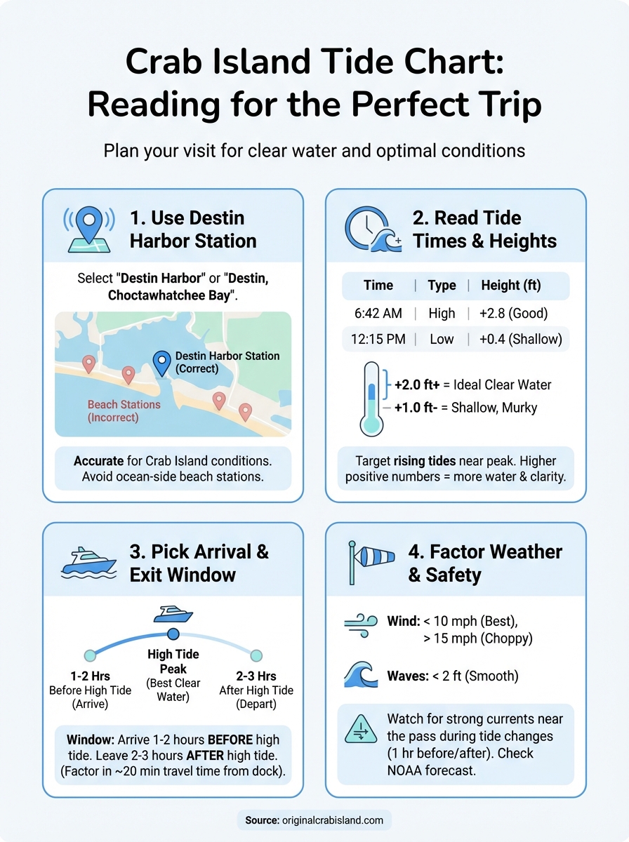
Step 1. Use the right tide station for Crab Island
The first step in reading a Crab Island tide chart is making sure you’re looking at data from the correct tide station. Not all stations in the Destin area provide accurate readings for Crab Island, and using the wrong one can throw off your timing by 30 minutes or more. You need tide predictions specifically for the Destin Harbor area to get reliable information.
Find the Destin Harbor tide station
Crab Island sits in the Choctawhatchee Bay near the Destin Pass, which means it follows the tidal patterns of Destin Harbor. When you search for tide information, look for stations labeled "Destin, Choctawhatchee Bay" or simply "Destin Harbor" in tide prediction services. These stations are positioned close enough to Crab Island to give you accurate timing and height data for planning your visit.
Using the Destin Harbor station ensures you get tide predictions within 5 to 10 minutes of actual conditions at Crab Island.
Avoid using stations from nearby beaches like Miramar Beach or Fort Walton Beach, as their ocean-side locations don’t reflect the bay conditions at Crab Island. The difference might seem small, but it can mean arriving during less ideal water clarity or struggling with unexpected currents.
Step 2. Read high and low tide times and heights
Once you’ve found the correct Destin Harbor station, you need to know how to interpret the tide information displayed on the chart. Every Crab Island tide chart shows you specific times when tides reach their high and low points, along with corresponding height measurements. This data tells you exactly what water conditions to expect at any given hour.
Locate the tide cycle information
Look for a table or list format that displays times in 12-hour or 24-hour format alongside labels like "High" and "Low." Each entry shows when a specific tide event occurs and how high or low the water will be at that moment. You’ll typically see four entries per day, alternating between high and low tides roughly every six hours.
Reading the exact times helps you plan your departure from the dock so you arrive at Crab Island during optimal conditions.
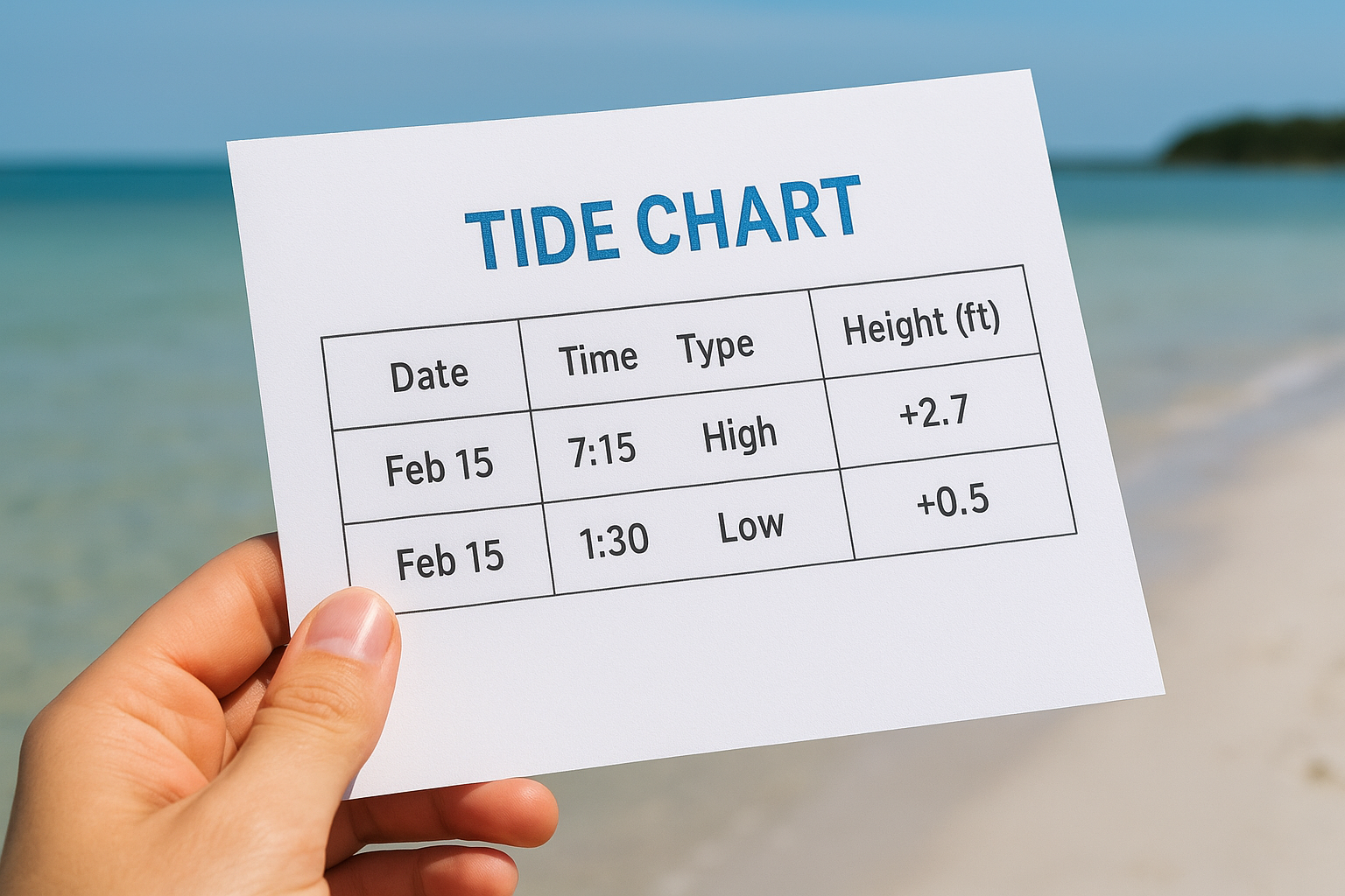
Most tide charts present this information like this:
| Date | Time | Type | Height (ft) |
|---|---|---|---|
| Feb 15 | 7:15 AM | High | +2.7 |
| Feb 15 | 1:30 PM | Low | +0.5 |
Interpret the height measurements
The height numbers tell you how much water covers the sandbar at different times. Positive numbers above +2.0 feet indicate good high tide conditions with clear water, while anything below +1.0 feet means shallow, potentially murky water. You want to target arrival times when heights are trending upward toward or at their daily peak.
Step 3. Pick the best arrival and exit window
After reading your Crab Island tide chart, you need to translate those numbers into actual arrival and departure times from the dock. The best window starts one to two hours before high tide and extends through the peak, giving you roughly three to four hours of ideal conditions. This timing ensures you arrive when water is clearing up and stay through the best part of the day.
Calculate your travel time from the dock
Your departure time from the marina depends on how far you’re traveling to reach Crab Island. Most boats take 15 to 20 minutes from Destin Harbor, but you should add extra time for loading, fueling, and navigating through the pass. If high tide hits at 2:00 PM, you want to leave the dock no later than 12:30 PM to arrive during the optimal window.
Arriving one hour before high tide gives you time to anchor and settle in before conditions peak.
Plan your exit strategy
You should start heading back before the tide drops significantly, typically two to three hours after high tide. Waiting too long means navigating out during falling tide when currents strengthen and visibility decreases. Using the earlier example with a 2:00 PM high tide, plan to depart Crab Island between 4:00 PM and 5:00 PM for the smoothest return trip.
Step 4. Factor in currents, weather, and safety
Your Crab Island tide chart gives you tide timing, but you also need to check weather conditions and water safety factors before finalizing your trip. Strong winds, high waves, or dangerous currents can turn an ideal tide window into an unsafe situation on the water. Combining tide information with current weather forecasts ensures you make smart decisions about when to visit.
Check wind speed and wave forecasts
Wind speeds above 15 mph create choppy conditions that make anchoring difficult and reduce your enjoyment at Crab Island. You should check the local marine forecast for Destin Harbor on the day of your trip, looking specifically for sustained wind speeds and wave heights. Calm winds under 10 mph with wave heights below 2 feet give you the smoothest experience.
Conditions can change quickly in the Gulf, so check forecasts the morning of your trip even if you planned days ahead.
Watch for current warnings in the pass
The Destin Pass between the bay and Gulf creates strong currents during tide changes, especially during new and full moons when tidal ranges increase. Your Crab Island tide chart shows when these transitions occur, and you should avoid navigating the pass during the hour immediately before and after tide changes. Local authorities post small craft advisories when currents become dangerous, which you can find through NOAA marine weather updates.
Next steps for your Crab Island trip
You now know how to read a Crab Island tide chart, identify the correct tide station for Destin Harbor, and plan your arrival window for the clearest water. The information you’ve learned gives you the foundation for timing your visit perfectly. Your next step is securing the right watercraft and equipment to actually get out there during your planned tide window.
Book your rental through Original Crab Island to ensure you have reliable equipment that matches your schedule. Their team coordinates departures based on daily tide predictions and current weather conditions, which means you won’t have to guess whether conditions will cooperate. Reserve your watercraft at least a few days ahead, especially during busy seasons when the best time slots fill quickly.
With your Crab Island tide chart knowledge and the right boat rental, you’re ready to experience Destin’s famous sandbar when conditions are at their peak.
For more options, explore our Original Crab Island services page.
Popular Crab Island Pages
- Crab Island Pontoon Rentals
- Crab Island Fishing Charters
- Crab Island Boat and Yacht Rentals
- Crab Island Parasailing
- Crab Island Jet Ski Rentals
- Crab Island Helicopter Rides
- Crab Island Snorkeling Tours
- Crab Island Paddleboard Rentals
- Crab Island Kayak Rentals
- Crab Island Bike Rentals
- Crab Island Shark Boat
- Crab Island Pirate Ship
- Crab Island Tiki Rentals
- Crab Island Snorkeling Tours